
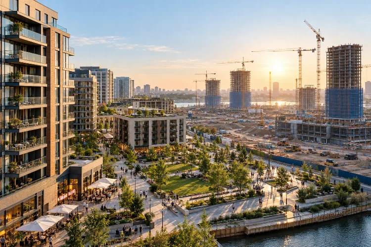
Imagine launching a new urban district with apartments, offices, shops, parks, and buzzing public spaces.
Now imagine trying to build all of it at once, while keeping costs under control and convincing people to move into a place that isn’t quite finished. Sounds complicated? It definitely is.
That’s why large mixed-use projects need more than an attractive master plan. They need a smart delivery strategy that turns a long-term vision into smaller, manageable steps.
Each step should attract investment, support daily life, and prepare the ground for whatever comes next.
Designing phased master plans for large mixed-use developments is essentially about balancing ambition with reality. Developers must deal with changing property markets, infrastructure costs, planning approvals, and community expectations, often over a decade or longer.
Yet the goal remains simple: create a district that feels connected and useful from its earliest opening, rather than waiting until the final building is complete. Here’s how to make that happen.
1. Why Phased Master Planning Matters
A traditional master plan shows the destination: buildings, streets, public spaces, and land uses arranged in a coherent layout.
A phased master plan also explains the journey. It identifies what can be delivered now, what depends on earlier investments, and what should remain adaptable.
That distinction matters because mixed-use districts operate on several different clocks.
Homes might sell quickly, office demand may take longer to emerge, and public transport upgrades can depend on government budgets. Construction schedules, meanwhile, rarely line up perfectly with market cycles.
Without a clear development sequence, the result can be expensive infrastructure serving empty plots, isolated residential towers, or retail spaces with too few customers.
Good phasing reduces those risks by matching each construction package to real demand and the facilities needed to support it.
Think in Outcomes, Not Just Construction Dates
Instead of defining Phase One as “three buildings completed by 2030,” define it as a walkable district with occupied homes, basic services, safe access, and usable outdoor space. Buildings are milestones, but a working neigborhood is the actual outcome.
This mindset makes the phasing strategy easier to explain to investors, city authorities, and future residents. Everyone can see what each stage is supposed to deliver, not merely how much floor area gets built.
2. Start With a Long-Term Vision and a Flexible Framework
Before choosing the first construction plot, establish the district’s long-term identity.
Is it a transit-oriented business hub, a family-friendly waterfront community, or a cultural destination with homes and workplaces? The answer influences block sizes, density, landscape, mobility, and the eventual mix of uses.
A useful framework defines street connections, public-space networks, development parcels, utility corridors, and environmental constraints.
It should also establish practical design rules for building heights, active ground floors, pedestrian comfort, and transitions to surrounding neighborhoods. These create consistency even when different architects and developers deliver separate phases.
Decide What Must Stay Fixed
Some choices are hard to reverse. Major roads, flood-protection levels, transit reservations, underground utilities, and the location of a central park usually need early decisions because later changes could be hugely disruptive.
Other details deserve room to evolve. A parcel originally intended for offices might eventually work better as housing, education, or flexible workspace, provided transport capacity and planning rules allow it.
Keeping that flexiblity in the framework is far more useful than pretending today’s forecast will stay accurate for fifteen years.
Digital master plan models can help teams test alternative land-use mixes and track how one change affects parking, water demand, public space, and construction access. Think of the model as a decision-making tool, not a glossy image that nobody updates.
3. Choose the Right Development Sequence
The first phase sets the tone for everything that follows. Ideally, it should have strong access, realistic market demand, manageable infrastructure requirements, and enough amenities to feel like a destination.
Starting with the most visually impressive parcel isn’t always the smartest move.
Developers should map critical dependencies before setting dates. A housing cluster may require a new access road and drainage system; a shopping street may need a minimum number of residents and workers; a school may depend on agreed population thresholds.
These relationships form the real logic behind the construction sequence.
Use an Illustrative Three-Phase Scenario
Consider a hypothetical 60-hectare site beside a railway station. Phase One might develop 12 hectares closest to transit, combining apartments, a modest retail strip, a public square, and essential utilities.
The aim is to establish a recognizable address without spending heavily on remote parcels.
Phase Two could extend the street grid, introduce more employment space, expand parks, and deliver community facilities as occupancy grows.
Phase Three might then accommodate larger commercial buildings or specialized uses once transport demand and leasing conditions justify them. The exact sequence should come from local feasibility studies, not a generic formula.
A strong plan also includes alternative routes. If office leasing slows, a pre-approved residential or institutional option could keep activity moving, assuming financial and infrastructure tests still pass. This is scenario planning, not indecision.
4. Make Every Phase Feel Like a Complete Place
One of the biggest mistakes in long-term developments is asking early residents to live beside an unfinished construction site with little else around them.
A successful first phase needs more than completed buildings. It needs shaded sidewalks, lighting, safe crossings, greenery, everyday services, and somewhere genuinely pleasant to spend time.
That doesn’t mean building every amenity on day one. A temporary community garden, pop-up market, small playground, or adaptable ground-floor unit can create social life before the permanent district center arrives.
The trick is to make temporary uses intentional, well managed, and easy to replace or relocate.
Design the Edges of Construction Carefully
The boundary between occupied areas and active building sites deserves serious attention.
Separate truck routes from pedestrian paths, control noise and dust, provide clear wayfinding, and avoid blocking the public spaces people already use. Each new phase should improve the experience of existing residents rather than undoing it.
Public spaces can also anchor the district’s identity early. At London’s King’s Cross, the redevelopment combined restored industrial buildings with new streets, squares, and parks, while the University of the Arts London moved into the Granary Complex in 2011.
That kind of early cultural activity gives people a reason to visit long before every parcel is developed.
5. Coordinate Infrastructure, Mobility, and Climate Resilience
Infrastructure is where phasing gets especially tricky. Building too little capacity creates expensive future upgrades, but installing oversized systems everywhere on day one can drain the project’s cash flow.
The solution is to distinguish essential backbone networks from connections that can be added as individual parcels come forward.
For example, the master plan may reserve a district-wide utility corridor and size strategic drainage routes for eventual demand, while installing local distribution lines in stages.
Engineers should test peak loads, spare capacity, maintenance access, and the cost of future connections before choosing a layout. Infrastrucure decisions need to support the whole district, not just the first contractor’s schedule.
Build Movement Networks Around People
Street layouts should connect the earliest occupied blocks to transit, neighboring communities, and useful destinations.
Pedestrian and cycling routes shouldn’t disappear each time a new plot starts construction. Where permanent streets aren’t ready, safe interim connections can keep the area usable.
NACTO’s street-design guidance describes existing, interim, and reconstructed conditions, including low-cost temporary changes that can test ideas before major investment.
That approach works well for emerging districts, provided temporary arrangements still meet relevant safety and accessibility standards.
Climate resilience needs the same forward-looking treatment. Reserve space for stormwater landscapes, shade trees, flood routes, and heat-reducing public spaces before parcels become too constrained.
The US Environmental Protection Agency highlights how green infrastructure such as rain gardens and permeable surfaces can help manage runoff and improve urban environments.
6. Match Land Use and Financing to Market Reality
A mixed-use land-use plan should balance residential, commercial, hospitality, community, and recreational activity over time.
But that doesn’t mean every phase needs an identical percentage of each use. Early phases often benefit from a smaller, realistic mix that creates demand for more specialized facilities later.
Retail is a good example. A beautifully designed shopping street can struggle when only a handful of homes are occupied. Starting with convenience services, cafés, and flexible smaller units may be more sensible than launching an entire shopping destination before its customer base exists.
Test the Cash Flow, Not Only the Final Value
Each phase needs a financial model covering land preparation, infrastructure, construction, approvals, leasing or sales, operating costs, and contingencies.
Compare different absorption rates, financing costs, and delays instead of relying on a single optimistic forecast. The most valuable end-state scheme isn’t automatically the most financeable delivery strategy.
The EPA’s work on smart-growth development discusses the business implications of horizontal infrastructure costs, construction phasing, and market acceptance.
Its broader economic research also points to potential efficiencies from compact, walkable development, although actual savings depend on location and project design.
Clear investment gates can help teams avoid building ahead of demand. For instance, a later office block might proceed only after a defined pre-leasing threshold, while a utility upgrade starts when approved load forecasts approach capacity.
These triggers should be reviewed regularly, with room for sound judgement when conditions shift.
7. Learn From Real Projects and Keep Adjusting the Plan
Two major European redevelopments show why a strong vision and ongoing adaptation belong together. King’s Cross in London received outline planning permission in 2006 for a district including roughly 50 new buildings, 20 new streets, and 10 major public spaces.
Early infrastructure and the reuse of heritage buildings helped turn a former industrial area into an active urban destination over time.
HafenCity in Hamburg offers an even clearer example of an evolving framework. Its original master plan was approved in 2000, but the eastern districts were substantially reconsidered in a 2010 revision as transport connections and planning conditions changed.
The revised framework increased planned gross floor area from 1.5 million to 2.4 million square meters, illustrating why a large district cannot be treated as a frozen blueprint.
Review Performance After Every Opening
Track more than construction progress. Monitor occupancy, retail performance, walking connections, public-space use, infrastructure capacity, resident feedback, and delivery costs.
These signals reveal whether the next phase needs a different building mix, an earlier park, or a better connection to public transport.
A simple quarterly dashboard can distinguish projects that are merely on schedule from places that are actually working.
Assign decision rights across the developer, planners, engineers, local authorities, and community representatives, so changes don’t disappear into endless coordiantion meetings.
The Urban Land Institute’s guidance on 15-minute communities reinforces the value of linking housing, mobility, community facilities, and infrastructure investments.
In practice, the strongest staged master plans are managed as living agreements: clear enough to guide delivery, but open enough to learn from the people already using the place.
Designing phased master plans for large mixed-use developments isn’t just about dividing a big project into smaller construction packages. It’s about deciding what makes each stage viable, connected, and worth experiencing while protecting the wider vision.
The best strategies combine a strong urban framework, realistic market sequencing, early public amenities, scalable infrastructure, and regular performance reviews. They also leave room for change, because cities and property markets never stand still.
If you’re planning a major mixed-use district, start by testing whether Phase One can thrive on its own and whether every later phase makes life better for the people already there.
Bring urban designers, engineers, financial advisors, and community stakeholders into that conversation early. That’s how a long-term blueprint becomes a place people actually want to use.